
The city of Brandon is the second largest city in Manitoba, Canada, with a population of nearly 60,000. The GIS department has been using FME Desktop and FME Server for several years now, with multiple data integration and validation processes currently up and running. Recently, in collaboration with Consortech, they set up Esri’s Operations Dashboard, backed by FME for the data preparation, to visualize and closely track the quality control processes for their spatial infrastructure database.
THE CHALLENGE
The visibility of GIS departments is often tied to the maps, dashboards and other applications that are made available to its customers. Behind the scenes, however, expectations are high about the quality of the data that feeds them. Organizations must therefore distribute their investments in time and financial resources between these two complementary components, and Brandon is no exception.
To create and maintain high-quality spatial databases, the Brandon GIS team chose to strategically invest in the quality control process. To do this, they had the great idea to capitalize on tools they already had to track their data validation processes on a virtual dashboard. As they already were both Esri and FME customers and familiar with ArcGIS Online, the obvious choice was to go with Esri’s Operations Dashboard to visualize and keep track of the quality of the data at any given moment.
Under the hood, FME Server enables the automation of the process that checks for errors and omissions in spatial infrastructure data. Some examples of datasets that go through the validation process include sewer, water, wastewater, drainage, buildings, roads, cycling paths and sidewalks. With FME, multiple aspects of the data are automatically validated:
- Spatial location
- Geometry correctness
- Attribute quality
- Completion
Once this strategy was well defined, they then contacted Consortech to use our Esri and FME expertise to help develop the complete solution.
HOW WE HELPED
Consortech worked closely with Brandon’s GIS team to understand what they wanted to see in their Operations Dashboard. Together, we planned to develop a new component in the existing validation workspace that connects directly to Operations Dashboard (in the Cloud). This process would run daily and update the dashboard with the validation status of the infrastructure data. Of course, there would be some data transformation to do as well: gathering statistics, trimming what is not necessary and modifying the data to fit how it needs to look in Operations Dashboard – all tasks that are in FME’s wheelhouse.
Consortech got to work on the development, maintaining open communication with the City’s GIS team for updates as required. The Operations Dashboard component was seamlessly added to their existing FME Workspace. The new process is scheduled to run daily on FME Server, and includes the following main steps:
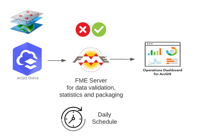
- FME connects directly to ArcGIS Online to read the data.
- FME checks the validation status, including errors that have been newly corrected, and generates required statistics such as the percentage of advancement of the corrections.
- FME connects to Operations Dashboard through ArcGIS Online to publish the validation statistics to a custom dashboard.
FME Server is successfully used behind the scenes to check the validation status of the spatial database and feed the custom statistics to Operations Dashboard in a seamlessly automated process.
THE VALUE WE PROVIDED
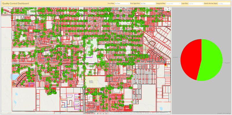
Thanks to the success of the project, the City of Brandon can keep a close eye on the quality control process for their spatial infrastructure database and create efficiencies in their data clean-up tasks. In addition, Operations Dashboard provides up-to-date clarity on the quality of the data, including:
- Infrastructure assets on the map
- Visual indicators of what has been corrected vs. what is left to do
- Statistics, such as percentage of errors corrected
- Filter according to criteria such as type of system, type of asset, etc.
The project took about one month to complete and has made data quality control more precise and efficient. As a result, it has increased the confidence of the City’s stakeholders and executives, who rely on them daily to make decisions that have a significant impact, both from a financial perspective and for the quality of life of residents. This project also brings great visibility to the GIS team, which demonstrates its ability to generate significant operational value to the City.
The enhancements Consortech made to our FME processes are an example of a quick-win strategy we like to use. Quickly scaling up existing technologies and solutions helped save time and money by improving the critical data validation and quality control process.